
Wind Hill Guidebook
Sightseeing
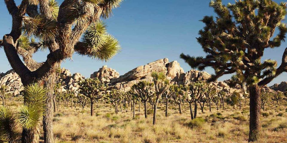
Joshua Tree National Park is a vast protected area in southern California. It's characterized by rugged rock formations and stark desert landscapes. Named for the regions twisted, bristled Joshua trees, the park straddles the cactus-dotted Colorado Desert and the Mojave Desert, which is higher and cooler. Keys View looks out over the Coachella Valley. Hiking trails weave through the boulders of Hidden Valley
1713 місцеві жителі рекомендують
Національний парк Джошуа-Трі
Joshua Tree National Park is a vast protected area in southern California. It's characterized by rugged rock formations and stark desert landscapes. Named for the regions twisted, bristled Joshua trees, the park straddles the cactus-dotted Colorado Desert and the Mojave Desert, which is higher and cooler. Keys View looks out over the Coachella Valley. Hiking trails weave through the boulders of Hidden Valley
On the outskirts of Joshua Tree, Southern Californias transcendental national park in the high desert, is Pioneertown, a 350-person hamlet unlike any other. Founded in the 1940s by a group of Western movie starsmost notably, Roy RogersPioneertown was created so they could shoot their films by day and perhaps live the life of a late-19th-century cowboy once the sun went down and the cameras stopped rolling. Pioneertown is exactly how you would imagine a Western set, with its faux saloon, trading post, and jail lining a dusty street in the middle of the desert. You would not be surprised if you saw a tumbleweed being carried along by the wind, and you might even feel inspired to purchase a pair of chaps and boots with spurs.
558 місцеві жителі рекомендують
Pioneertown
53688 Pioneertown RdOn the outskirts of Joshua Tree, Southern Californias transcendental national park in the high desert, is Pioneertown, a 350-person hamlet unlike any other. Founded in the 1940s by a group of Western movie starsmost notably, Roy RogersPioneertown was created so they could shoot their films by day and perhaps live the life of a late-19th-century cowboy once the sun went down and the cameras stopped rolling. Pioneertown is exactly how you would imagine a Western set, with its faux saloon, trading post, and jail lining a dusty street in the middle of the desert. You would not be surprised if you saw a tumbleweed being carried along by the wind, and you might even feel inspired to purchase a pair of chaps and boots with spurs.
The Hidden Valley Nature Trail is an enjoyable one-mile loop trail that enters through an opening into a large bowl surrounded by rock walls. It's thought that due to the geography, Hidden Valley was once used by cattle rustlers, who would herd the cattle into this area to conceal them.
113 місцеві жителі рекомендують
Природний маршрут Hidden Valley
74485 National Park DriveThe Hidden Valley Nature Trail is an enjoyable one-mile loop trail that enters through an opening into a large bowl surrounded by rock walls. It's thought that due to the geography, Hidden Valley was once used by cattle rustlers, who would herd the cattle into this area to conceal them.
It is well worth the drive up to Keys View, a lookout point at an elevation of more than 5,000 feet, with sweeping views extending out over the Coachella Valley. In the distance, you can see the San Andreas fault line, Palm Springs, the Salton Sea, and on a clear day, beyond to Mexico. If the air is clear, the view is spectacular and this is a great way to get oriented with the surrounding geography.
109 місцеві жителі рекомендують
Keys View
It is well worth the drive up to Keys View, a lookout point at an elevation of more than 5,000 feet, with sweeping views extending out over the Coachella Valley. In the distance, you can see the San Andreas fault line, Palm Springs, the Salton Sea, and on a clear day, beyond to Mexico. If the air is clear, the view is spectacular and this is a great way to get oriented with the surrounding geography.
Another short walking path, Barker Dam is a 1.3-mile loop trail. If you are only looking to do one short trail in Joshua Tree, this is your best bet, with huge Joshua trees, rocks, and an area of water that often attracts birds.
At the far end of the loop are the remnants of a water tank left by cattle ranchers who once lived in the area. Many people walk in to this point and turn around, leaving by the same route, but this is a mistake. While this might be slightly shorter, it is well worth continuing on, with much of the best scenery and largest trees on the loop beyond the dam.
81 місцеві жителі рекомендують
Barker Dam Nature Trail
Barker Dam Nature TrailAnother short walking path, Barker Dam is a 1.3-mile loop trail. If you are only looking to do one short trail in Joshua Tree, this is your best bet, with huge Joshua trees, rocks, and an area of water that often attracts birds.
At the far end of the loop are the remnants of a water tank left by cattle ranchers who once lived in the area. Many people walk in to this point and turn around, leaving by the same route, but this is a mistake. While this might be slightly shorter, it is well worth continuing on, with much of the best scenery and largest trees on the loop beyond the dam.
Perhaps nowhere else in the park is the almost comic book landscape more finely illustrated than at Skull Rock. You may see faces and images in the rock formations that dominate the park, but at Skull Rock it takes very little imagination to see the skull shape peering out of the boulder-strewn rubble. This huge, naturally sculpted rock is located right beside the road, and it always draws a crowd.
The whole area around this roadside stop is interesting, with an expanse of rolling rock piles, great for walking or light scrambling. Remnants of trails run through the area, but many people just wander about, finding high points for lookouts, sunning themselves on the slabs of rock, or simply taking a break. Across the street is a 1.7-mile hiking trail through rocks and shrubby vegetation with a few Joshua trees scattered around.
Skull Rock
Temescal Canyon RoadPerhaps nowhere else in the park is the almost comic book landscape more finely illustrated than at Skull Rock. You may see faces and images in the rock formations that dominate the park, but at Skull Rock it takes very little imagination to see the skull shape peering out of the boulder-strewn rubble. This huge, naturally sculpted rock is located right beside the road, and it always draws a crowd.
The whole area around this roadside stop is interesting, with an expanse of rolling rock piles, great for walking or light scrambling. Remnants of trails run through the area, but many people just wander about, finding high points for lookouts, sunning themselves on the slabs of rock, or simply taking a break. Across the street is a 1.7-mile hiking trail through rocks and shrubby vegetation with a few Joshua trees scattered around.
In an area that few people would describe as hospitable are the remains of Keys Ranch, the former homestead and ranch of William F. Keys, who settled in this area in the 1910s.
The property, which includes the house, schoolhouse, store, and workshop, is a National Historic Register Site and can only be visited on ranger-led guided tours. These tours run seasonally throughout the winter and into spring.
The tours are very informative and provide insight into Keys, who was quite a character, and the challenges faced by the family and ingenuity required to live out here. See the park website for information on tour dates and times.
Reservations are required and can be made up to 60 days in advance. The 90-minute tours are offered at a fee and involve a half-mile of walking.
33 місцеві жителі рекомендують
Keys Ranch
In an area that few people would describe as hospitable are the remains of Keys Ranch, the former homestead and ranch of William F. Keys, who settled in this area in the 1910s.
The property, which includes the house, schoolhouse, store, and workshop, is a National Historic Register Site and can only be visited on ranger-led guided tours. These tours run seasonally throughout the winter and into spring.
The tours are very informative and provide insight into Keys, who was quite a character, and the challenges faced by the family and ingenuity required to live out here. See the park website for information on tour dates and times.
Reservations are required and can be made up to 60 days in advance. The 90-minute tours are offered at a fee and involve a half-mile of walking.